Airports
Jump to navigation
Jump to search
Care-Flight regularly lands a medivac helicopter in Gerlach.
Below is an alphabetical list of local airports and landing strips.
Black Rock City Airport
Active during Burning Man.
Visual Flight Rules (VFR) charts show the Black Rock City Airport with a purple circle containing an R, indicating that the landing strip is Restricted.
- GNIS
- "Citation: Citation Unknown"
- "Entry Date: 13-Apr-2013"
- Black Rock City Airport (AirNav)
- Activation date: 07/2009
Crossley 99 Ranch
- The 1973 edition of the Lovelock 1:250,000 1955 map shows an airstrip at Crossley 99 Ranch, located at present-day Orient Farms.
Empire Airport 1A8
- GNIS
- "Citation: Federal Aviation Administration (FAA) listing of airports and other landing areas in the United States with associated information, 1981. Now available in CD format published quarterly. The year and month of the CD follows if known: 882803"
- "Entry Date: 01-Sep-1989"
- Empire 1A8 (AirNav)
- Activation date: 04/1987
- Nevada DOT, Empire Airfield (Dead as of 2014-01-01, see archive.org
Gerlach Landing Strip
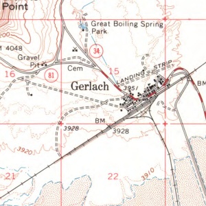
There is an abandoned landing strip at the north edge of Gerlach.
Visual Flight Rules (VFR) charts show the Gerlach Landing Strip with a purple circle containing a U, indicating that the landing strip is Unverified.

- GNIS
- "Citation: U.S. Department of the Interior, U.S. Geological Survey, 1:250,000-scale topographic maps; various edition dates. Represents new or changed names from published editions. Map name and year of publication follow (if known): Lovelock/1970"
Soldier Meadow Number 1 Airport
Private, request permission before use.
- 41.3850337, -119.1685116
- GNIS
- "Citation: Global Air,AirNav, USGS and FAA. Public and Private Airports of the United States. www.globalair.com, www.airnav.com, www.faa.gov, www.usgs.gov. 24-FEB-2011. 2009 NAIP Imagery and ESRI ArcGISOnline Imagery."
- "Entry Date: 01-Sep-1989"
- 864061|Soldier Meadow Number 1 Airport|Airport|NV|32|Humboldt|013|412306N|1191007W|41.3850337|-119.1685116|||||1368|4488|Soldier Meadow|09/01/1989|06/23/2021
- Soldier Meadow Nr 1 Airport (Air Nav)
- 45 miles NE of GERLACH, NV
- Activation Date: 01/1960
Soldier Meadow Number 2 Airport
Private, request permission before use.
- 41.1221738, -119.137935
- GNIS
- "Citation: Global Air,AirNav, USGS and FAA. Public and Private Airports of the United States. www.globalair.com, www.airnav.com, www.faa.gov, www.usgs.gov. 24-FEB-2011. 2009 NAIP Imagery and ESRI ArcGISOnline Imagery."
- "Entry Date: 01-Sep-1989"
- 864060|Soldier Meadow Number 2 Airport|Airport|NV|32|Humboldt|013|410720N|1190817W|41.1221738|-119.137935|||||1236|4055|Donnelly Creek|09/01/1989|06/23/2021
- Soldier Meadow Nr 2 Airport (Air Nav)
- 30 miles NE of GERLACH, NV
- Activation Date: 01/1960
- To the west of Wheeler Ranch adjacent to the Soldier Meadows Road
- The Vya 1:250,000 1954 (1967 ed.) names it as Van Vleck (pvt.)
- The Vya 1:250,000 1954 (1973 ed.) names it as Parman
Sulphur Airport
Not shown on VFR Charts, but on topo maps
- GNIS
- "Citation: Citation Unknown"
- "Entry Date: 01-Jul-1991"
- Sulphur Landing Strip (Alternate name): "'State of Nevada Airports and Landing Strips 1991': Nevada Department of Transportation Planning Division, 1991, scale 1 inch=22 miles approx. Planimetric map showing classes of airports and their locations. 1991"
Summit Lake Landing Strip
Shown as Unverified on VFR charts.
- GNIS
- "Citation: Bureau of Land Management (BLM) maps other than 1:100,000-scale and 1:126,720-scale (1/2 inch = 1 mile). The name and year of publication follow (if known): Salem Westside Recreation Map 1996 Virgin Creek/1971"
- Note that "Salem Westside Recreation Map 1996" is probably a typo. http://www.blm.gov/or/pubroom/files/Oregon_Recreation_Map_Index.pdf indicates that a map with the same name covers northwestern Oregon.
- "Entry Date: 01-Oct-1991"
- "Citation: Bureau of Land Management (BLM) maps other than 1:100,000-scale and 1:126,720-scale (1/2 inch = 1 mile). The name and year of publication follow (if known): Salem Westside Recreation Map 1996 Virgin Creek/1971"
See Also
External Links
- Paul Freeman, "Abandoned & Little-Known Airfields: Northwestern Nevada"
- SkyVector.com, Aeronautical Charts - Flight Planning