Search results
Jump to navigation
Jump to search
Page title matches
- ...ne, which is visible for miles. The mine is also named the "White Blowout Mine".<ref name="bateman">Paul C. Bateman, "[http://www.nbmg.unr.edu/scans/3400/ The mine was in operation in the 1950s, when between 1 and 10 tons of 60% WO3 concen ...2 KB (369 words) - 20:33, 28 December 2021
- ...e located south of the [[Mountain View Exploration Project | Mountain View Mine]] in [[Squaw Valley]]. ...f>"[https://mrdata.usgs.gov/mrds/show-mrds.php?dep_id=10296329 Silver Bell Mine]," USGS</ref> and Tungsten were reported. ...1 KB (154 words) - 04:13, 25 February 2022
- ...ef>"[https://westernmininghistory.com/mine-detail/10045037/ Roberts Copper Mine]," Western Mining History.</ref> In 1978, Jesse Miller lived at the Roberts Copper Mine.<ref>"[https://www.newspapers.com/article/reno-gazette-journal-new-trial-da ...858 bytes (110 words) - 04:42, 1 April 2024
- The Wild Horse Canyon Mine is in the [[Cottonwood Mining District]] east of the [[Smoke Creek Desert]] * Tim Purdy, "[http://www.tipurdy.org/wild-horse-mine/ Wild Horse Mine] ...479 bytes (65 words) - 06:27, 21 November 2016
- UPDATE Fall 2010: apparently the mine has been closed. [[Image:Royal Rainbow Opal Mine view.jpg|frame|View from Royal Rainbow Opal Mine, looking southeast towards Black Rock Point]] ...2 KB (254 words) - 05:59, 23 October 2023
- One source (Castor and Ferdock) place the Auld Lang Syne Mine in the Blue Wing Mountains, where as many other sources place the Auld Lang Castor and Ferdock state that Chiastolite is found at the Auld Lang Syne Mine in the [[Blue Wing Mountains]].<ref>Stephen B. Castor, Gregory C. Ferdock, ...2 KB (347 words) - 20:34, 28 December 2021
- #REDIRECT [[White Caps Mine]] ...29 bytes (4 words) - 04:16, 17 May 2015
 (640 × 480 (70 KB)) - 02:22, 8 October 2008
- 24 bytes (3 words) - 17:48, 17 February 2013

Page text matches
- The Jumbo Mine is a former gold mine located in the [[Slumbering Hills]] region, 30 miles northwest of Winnemucc ...&rtserp=tags/?psi=63&pci=7&pf=clyde&pl=taylor Skaggs Seeking another Jumbo Mine]," September 23, 1936, p. 6</ref> ...3 KB (454 words) - 20:34, 28 December 2021
 Patent for gypsum mine at what was to be Empire. ...(158 KB) - 02:51, 9 July 2020
- ...ne, which is visible for miles. The mine is also named the "White Blowout Mine".<ref name="bateman">Paul C. Bateman, "[http://www.nbmg.unr.edu/scans/3400/ The mine was in operation in the 1950s, when between 1 and 10 tons of 60% WO3 concen ...2 KB (369 words) - 20:33, 28 December 2021
- * [[Mountain View Exploration Project | Mountain View Mine]] * [[Silver Bell Mine]] ...576 bytes (83 words) - 04:00, 25 February 2022
- * Hawkeye Mine * Keough-Noble Mine ...2 KB (344 words) - 20:34, 28 December 2021
- The Iron King Mine is a former iron mine located in the located in the [[Jackson Mountains Mining District]]<ref nam The mine was held by the DeLong Brothers and leased by W. G. Austin and Tom Beko<ref ...3 KB (471 words) - 17:58, 4 August 2022
- The [[Silver Bell Mine]] is part of the Mountain View Exploration Project. In 1942, Giannelli describes the Mountain View mine and George Nash's nearby tungsten claim.<ref>"[http://ronhess.info/MD/scans ...2 KB (250 words) - 04:14, 25 February 2022
- The Cassidy Mine is 3.5 miles from Highway 34 on the edge of the Black Rock Playa. The Cassidy Mine is considered to be in the [[Trego Mining District]]. ...2 KB (224 words) - 16:32, 6 March 2024
- One source (Castor and Ferdock) place the Auld Lang Syne Mine in the Blue Wing Mountains, where as many other sources place the Auld Lang Castor and Ferdock state that Chiastolite is found at the Auld Lang Syne Mine in the [[Blue Wing Mountains]].<ref>Stephen B. Castor, Gregory C. Ferdock, ...2 KB (347 words) - 20:34, 28 December 2021
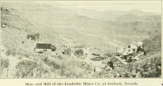 "Mine and Mill of [[Leadville]] Mines Co. at Gerlach, Nevada" c. 1921. From [htt ...(1,502 × 795 (1.06 MB)) - 06:54, 24 November 2014
- ...Raser, [[James Raser]] and others were directors of the Donnelly Mountain Mine Co. in the [[Donnelly District]]. ...143 bytes (20 words) - 18:48, 27 November 2014
- ...rces of the Kumiva Peak 30" by 60" quadrangle]]," Description of the Sano mine, developed in the 1920's. * [[Sano Consolidated Mine]] ...1 KB (162 words) - 17:35, 1 September 2020
- The Jeakins Mine is located in the [[Selenite Range]]. ...6 miles north of Trego?<ref>[http://search.proquest.com/docview/163316222 Mine Prospect of Old-Timer in Shipping Class]," Los Angeles Times, 1935-Mar-11. ...2 KB (340 words) - 06:47, 20 June 2017
- ...cated on the southeast flank of the [[Granite Range]] near [[Water Tunnels Mine]]. ...237 bytes (30 words) - 20:34, 28 December 2021
- ...ards-58287942.html Golden Phoenix to be Honored for Its Ashdown Molybdenum Mine by Nevada Governor at Annual Industry Appreciation Awards,]" October 2007.< The mine was listed as being operational in 2012 with 35 employees and having produc ...2 KB (314 words) - 16:16, 2 February 2024
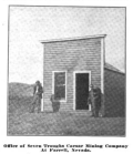 ...Mining Investor]," Volumes 50-51, p. 226, 1908. Photos of the Kindergarten mine, Seven Troughs and Mazuma. ...(900 × 1,042 (493 KB)) - 19:57, 23 December 2014
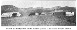 ...Mining Investor]," Volumes 50-51, p. 226, 1908. Photos of the Kindergarten mine, Seven Troughs and Mazuma. ...(1,674 × 650 (650 KB)) - 20:51, 23 December 2014
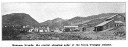 ...Mining Investor]," Volumes 50-51, p. 225, 1908. Photos of the Kindergarten mine, Seven Troughs and Mazuma. ...(1,676 × 614 (610 KB)) - 20:09, 23 December 2014
- ...><ref>"[https://westernmininghistory.com/mine-detail/10045001/ Nevada King Mine]," Western Mining History.</ref> "Boyd Basin district The Homer Verne mine was operated from April to November 1936 under lease and produced a small q ...2 KB (307 words) - 05:44, 8 May 2024
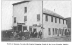 ...ng Investor]," Volumes 50-51, p. 246-248, 1908. Photos of the Kindergarten mine, Seven Troughs and Mazuma. ...(1,720 × 1,066 (971 KB)) - 20:12, 23 December 2014


