Mud Meadow
Mud Meadow is located 0.7 mi west of Mud Meadow Reservoir and the Van Vleck Dam on the road to Soldier Meadows (located about 4 miles to the north).
Joseph Goldsborough Bruff traveled through the area in 1849 and drew a landscape of a Singular volcanic formation[1].
An 1865 article states that Mud Meadows was 16 miles from Fountain Spring and 14 miles from Soldiers Meadows on the Susanville/Idaho stage line.[2]
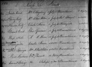
The Mud Meadows Post Office was located here from February 1867 until August 1867.
In 1877, Thomas W. Symons traveled through the area: " High Rock Canon is a very long and very narrow cation generally from 50 to 200 yards in width with vertical walls two to five hundred feet in height. We traveled for nearly 40 miles through the canon, and, emerging therefrom proceeded on to Mud Meadows the residence of Mr Wenner one of the large cattle owners of the country. This Mud Meadows lie on the borders of the great Black Rock Desert and are the wintering place for a goodly number of cattle. Here Piute Peak was occupied as a triangulation station and we moved on to the southwest up Little High Rock Canon along the face of a white crumbling cliff under overhanging rocks and by a little lake which forms the sink for the waters which come down from High Rock and its branch canons; thence across the hills to a spring under Division Peak which was next occupied."[3]

References
- ↑ Joseph Goldsborough Bruff, "Diary of J.G. Bruff, Singular volcanic formation, Mud Meadow," 1849.
- ↑ "Distances from Susanville to Ruby City," October 28, 1865, The Weekly Union Record, Oroville, p. 2.
- ↑ Thomas W. Symons, "Executive and Descriptive Report of Lieutenant Thomas W. Symonds Corp of Engineers on the operations of Party No 1 California Section Field Season of 1877," p. 113, 1878. In Alvin R. McLane "Silent Cordilleras, The Mountain Ranges of Nevada", p. 19, Reno: Camp Nevada Monograph Number 4, 1978, 118 pp.