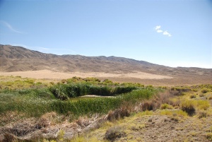
Rabbithole Springs
Rabbit Hole Springs was the last water before Black Rock Point on the Applegate-Lassen Trail. In 1849, Joseph Goldsborough Bruff stated that there were many dead animals around Rabbit Hole. In August, 1860, Frederick W. Lander built an 80,000 gallon concrete tank at Rabbit Hole.


"Great numbers of rabbits came around us and we killed all we wanted of them. This is the place always since known as the Rabbit Hole Springs." Lindsay Applegate, 1846
Rabbithole Springs vs Rabbit Hole Springs
There are various spellings. The USGS Map says "Rabbithole Springs". "Rabbit Hole Springs" is what was used by pioneers.
- GNIS Rabbithole (historical) has these citations:
- GNIS Rabbit Hall: "Rand McNally and Co. 'Pocket Map and Shippers Guide of Nevada', New York, 1901, 20 pages, plus plate, 1 inch = 27 miles. p13"
- GNIS Rabbit Hole: "Lincoln, Francis Church. Mining Districts and Mineral Resources of Nevada. Verdi, Nev.: Nevada Newsletter Publishing Co., 1923, 295 pp. Lengthy discussion of mining districts in Nevada, their various names, their history, and their mineral resources. p212"
- GNIS Rabbithole Springs: "Paher, Stanley W. Nevada Ghost Towns and Mining Camps. Berkeley: Howell-North Books, 1970, 492 pp. Gives historical background for mining towns and camps in Nevada. p123"
- GNIS Rabbit Hole Springs: "(Flying A) Smiling Associated Dealers, Official Road Map California Nevada, Chicago: H.M. Gousha Co., 1938, 1 inch = 35 miles. An old-fashioned oil company road map.
- GNIS Rabbithole Springs seems to be preferred, but that seems like it uses the most recent citation?
- GNIS Rabbit Hole Spring: "The American Guide Series, Compiled and Written by the Federal Writers' Project of the Work Projects Administration. A state by state guide series published by various publishers, in the late 1930's and 1940's. Each book studies and describes each state's history, natural endowments, and special interests. Use code US-T125/Name/YYYY/p#. OriginPlaceNames/1941/p65"
- GNIS Rabbit Hole Springs: "Sacramento Daily Union Newspaper, August 26, 1864. Letters from Nevada Territory (by G.K.G.)" (Different citation than from above)
- GNIS Rabbit Spring: "Degroot's Map of Nevada Territory, exhibiting a portion of southern Oregon and eastern California, with county boundaries, mining districts, etc.: 1863, scale 1 inch=12.25 miles. Warren Holt, Publisher, 305 Montgomery St., San Francisco, Calif. Entered according to an act of Congress in the year 1862 by Warren Holt in the Clerk's Office of the District Court for the Northern District of California, R. Jordan."
- GNIS Rabbit Springs: "The American Guide Series, Compiled and Written by the Federal Writers' Project of the Work Projects Administration. A state by state guide series published by various publishers, in the late 1930's and 1940's. Each book studies and describes each state's history, natural endowments, and special interests. Use code US-T125/Name/YYYY/p#. OriginPlaceNames/1941/p65" (Same citation as for Rabbit Hole Spring?)
- GNIS Rabbithole Spring: "Bureau of Land Management (BLM) maps other than 1:100,000-scale and 1:126,720-scale (1/2 inch = 1 mile). The name and year of publication follow (if known): Salem Westside Recreation Map 1996 Grazing Status Map 22/1960"
- Note that "Salem Westside Recreation Map 1996" is probably a typo. http://www.blm.gov/or/pubroom/files/Oregon_Recreation_Map_Index.pdf indicates that a map with the same name covers northwestern Oregon.
Nevada Outdoor School's emigranthistoryrabbithole.doc
Emigrant History
Water is scarce along the Applegate Trail; however, there were several main locations that emigrants depended upon for their water supply.
These locations were: Antelope Springs, Rabbit Hole Spring, Black Rock Hot Spring, Double Hot Springs, Mud Meadow and High Rock Lake.
During the massive westward emigration in 1849, many emigrants found the spring at Rabbit Hole disappointing. The Applegate’s blazed the trail for the purposes of Oregon-bound emigrants and as an escape route in the event of hostile interaction with the British. The trail was not meant for the passage of thousands of emigrants in 1849. Consequently, Rabbit Hole was less of an oasis and more of a frustration for weary, thirsty travelers. Wells had to be dug in order to retrieve a decent amount of water, and if one arrived later in the day, especially later in the year, the water supply was certain to be low.
Dodd, Charles H. The Emigrant Experience. 19th Century Productions. Chilcoot, CA. 2001. McGuckian, Peggy. Emigrant Trails in the Black Rock Desert. U.S. Department of the Interior Bureau of Land Management. Winnemucca, NV. 1978.
References
- GNIS Map
- "Voltigeur," "Letter Fromm Lander's Expedition," August, 1860. Includes a description of improvements to Rabbit Hole Spring.
- Gary L. Ecelbarger, "Frederick W. Lander: The Great Natural American Soldier." Description of the size of the tank.
See Also
- H.F. Bonham, Jr., L.J. Garside, R.B. Jones, K.G. Papke, J.Quade, and J.V. Tingle, "OF1985-03: A mineral inventory of the Paradise-Denio -- and Sonoma-Gerlach Resource Areas, Winnemucca District, Nevada," p. 126, 1985.
Images
- "Rigors of the trail: A Traveler's View, p. 80, April, 20, 1959, Life Magazine. Drawing of Rabbit Hole Spring by Joseph Goldsborough Bruff.
- Henry Lind, "Henry Lind Album", 1941.
- sc20012.jpg: "At Rabbit Hole Springs, Nevada. An important spot to emigrants. Water was scarce in former days and scarce now. Dry placering for gold was carried on in the Rabbit Hole District in recent years."
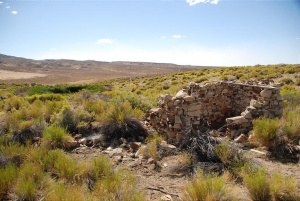
- sc20013.jpg: "Rock Hut built over Rabbit Hole Spring. Used by placer miners as 'cooler' for supplies."
- Craig Sheppard, "Rabbit Hole Springs, 1849, painting, 2004.117, Special Collections Department, University of Nevada, Reno.