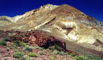
Calico Hills

The Calico Mountains are located on the west-north-western edge of the Black Rock Desert Nevada,
bounded by Hualapai Valley on the west, Donneley Peak on the northwest and the Playa on the east
- view from Steamboat hill of eastern side, taken from http://ian.kluft.com/blackrock/paragon-d2-200309/wed.html
- http://130.166.124.2/nv_panorama_atlas/page17/files/page17-1014-thumb.jpg http://130.166.124.2/nv_panorama_atlas/page17/files/page17-1014-full.html 130.166.124.2/nv_panorama_atlas/page17/files/page17-1014-full.html -- Nevada Atlas of Panoramic Aerial Images, Washoe County, Hualapai Flat - The Calico Range is located in the very center of the image
http://www.calicomtns.net/ www.calicomtns.net/ --
The Calico Mountains & the Calico Complex of Wild Horse Herd Areas
The Calico Mountains area north of Gerlach, NV, is home to a wonderful and unique herd of wild horses. Just like the well-known Kiger, Pryor Mountain, and Sulfur Springs herds, many herd areas in the BLM system have wonderful distinct & unique qualities. The Calico Mountains is one such area - not the same as the Kigers, etc, but deserving of more recognition and careful management, to preserve the uniqueness and high quality of the horses who live here. Learn about these horses and the unique ecological and historical environment that surrounds them.