Tohakum Peak

From Black Rock Desert Wiki
Revision as of 03:13, 2 September 2017 by Cxbrx (talk | contribs) (Image of the burn scar)
Jump to navigation Jump to search

Tohakum Peak is located in the Lake Range.

Carlson states that Tohakum means hare or white rabbit.[1]

In 2017, The Tohakum 2 fire burned at least 52,704 acres. On August 29, 2017 at 7:28 p.m., it started near mile marker 30 of Highway 447. 447 was closed until 7:30am on August 31, 2017.
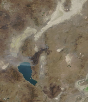
The Tohakum2 fire is shown in this satellite image from https://worldview.earthdata.nasa.gov/ dated September 1, 2017. In this image, the burn scar can be seen running north east from Pyramid Lake, crossing highway 447 and the Selenite Range.

References

  1. Helen S. Carlson, "Nevada Place Names," p. 3.