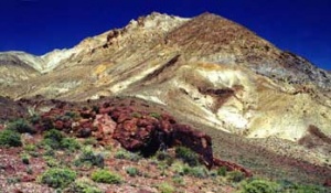
Calico Hills

The Calico Hills are located on the west-north-western edge of the Black Rock Desert Nevada, bounded by Hualapai Valley on the west, Donnelly Peak (in the Donnelly District) on the northwest, and the Black Rock Desert playa on the east.
Calico Hills vs. Calico Mountains
The GNIS entry for the Calico Mountains[1] is for a location about 110 miles north east of the Calico Range. Thus, the correct name for the Calicos near the Black Rock Desert is "Calico Hills."
The earliest reference for Calico Hills is a 1911 article, "Big Niter Field in the Calico Hills"[2]. See Nitrate for details.
In 1975, the U.S. Geographic Names Board wrote: "Calico Hills: mountains, 17.7 km. (11 mi.) long and 8.1 km. (5 mi.) across, extend S from Division Peak 34 km. (21 mi.) NNE of Gerlach; name derived from appearance of the mountains' alternating light and dark strata; Pershing and Humboldt Cos., Nev. ; 41°04 '00" N, 119°12 '00" W (N end), 40°55'00" N, 119°15'00" W (S end). Variant: Calico Mountains.[3]"
In 1989, "Agenda Item 2.B.(4). Deferral for second reading of terminology Calico Hills vs. Calico Mountains. Controversy was reviewd. Although the Board had approved the terminology "Calico Mountains" at its previous meeting, recent communication with the USBGN indicated that the term "Calico Hills" was already approved the that agency in 1975. The Board passed a motion to discontinue its consideration of the matter."[4]
The "Calico Mountains" & the Calico Complex of Wild Horse Herd Areas are the names used by the BLM to manage the wild horses in this area, even though the name Calico Mountains refers to a different mountain range in Humboldt County.
See Also
Resources
- ↑ GNIS Calico Mountains - these mountains are located east of US 95, fairly far from the Calico Hills.
- ↑ Niter Field in Calico Hills," San Francisco Call, Volume 110, Number 8, 8 June 1911.
- ↑ "Decisions on geographic names in the United States," Decision List 7502, April-June, 1975. In no.7301-7604 1973-1976.
- ↑ "Nevada State Board of Names, January 11, 1989.
- GNIS Calico Hills
- Citation: "U.S. Geological Survey. Geographic Names Phase I data compilation (1976-1981). 31-Dec-1981. Primarily from U.S. Geological Survey 1:24,000-scale topographic maps (or 1:25K, Puerto Rico 1:20K) and from U.S. Board on Geographic Names files. In some instances, from 1:62,500 scale or 1:250,000 scale maps."
- Variant Name: Calico Mountains, Citation: "U.S. Geological Survey. Geographic Names Phase I data compilation (1976-1981). 31-Dec-1981. Primarily from U.S. Geological Survey 1:24,000-scale topographic maps (or 1:25K, Puerto Rico 1:20K) and from U.S. Board on Geographic Names files. In some instances, from 1:62,500 scale or 1:250,000 scale maps."
- Variant Name: Forman Mountains, Citation: "McLane, Alvin R. 'Silent Cordilleras, The Mountain Ranges of Nevada' Reno: Camp Nevada Monograph Number 4, 1978, 118 pp. Descriptions of the mountain ranges of Nevada, including alternate names and history. p32"
- Variant Name: Harlequin Hills, Citation: "McLane, Alvin R. 'Silent Cordilleras, The Mountain Ranges of Nevada' Reno: Camp Nevada Monograph Number 4, 1978, 118 pp. Descriptions of the mountain ranges of Nevada, including alternate names and history. p32"
- Carlson states that the name Harlequin was for the many-colored costume worn by "traditional pantomimests", Helen S. Carlson, "Nevada Place Names: A Geographical Dictionary," p. 66.
- Correspondance: Letter from the Nevada Division of Water Resources stating no objection, 1975.
- Forms: 1972 form proposing Calico Hills
- Forms: 1975 form proposing Calico Hills
- Wikipedia
- nevadawilderness/northwest/calicomtns.htm Calico Mountains Wilderness