Historic Maps: Difference between revisions
Jump to navigation
Jump to search
Nevada DOT Maps |
Fixed dates. |
||
| Line 19: | Line 19: | ||
* [[1896 Post Route Map]] | * [[1896 Post Route Map]] | ||
* 1918 [http://content.lib.washington.edu/u?/fishimages,38976 Map of Lake Lahontan, showing water area and boundary of hydrographic basin] from "Fishes of the Lahontan System of Nevada and Northeastern California" map is by Israel C. Russell, probably a duplicate of the 1883 version?(University of Washington) | * 1918 [http://content.lib.washington.edu/u?/fishimages,38976 Map of Lake Lahontan, showing water area and boundary of hydrographic basin] from "Fishes of the Lahontan System of Nevada and Northeastern California" map is by Israel C. Russell, probably a duplicate of the 1883 version?(University of Washington) | ||
* [https://nevadadot.com/Traveler_Info/Maps/Historic_Humboldt.aspx Humboldt County (NV DOT | * 1937, 1960 [https://nevadadot.com/Traveler_Info/Maps/Historic_Humboldt.aspx Humboldt County (NV DOT)] | ||
* [https://nevadadot.com/Traveler_Info/Maps/Historic_Washoe.aspx Pershing County (NV DOT | * 1937, 1948, 1968 [https://nevadadot.com/Traveler_Info/Maps/Historic_Washoe.aspx Pershing County (NV DOT)] | ||
* [https://nevadadot.com/Traveler_Info/Maps/Historic_Washoe.aspx Washoe County (NV DOT | * 1937, 1948, 1965 [https://nevadadot.com/Traveler_Info/Maps/Historic_Washoe.aspx Washoe County (NV DOT)] | ||
* Washoe and Storey Counties, Nevada. [[Harry Freese]] (1953) | * Washoe and Storey Counties, Nevada. [[Harry Freese]] (1953) | ||
* [http://www.mapcruzin.com/download-topo-maps/txu-pclmaps-topo-us-vya-1961.jpg Vya | * 1961 [http://www.mapcruzin.com/download-topo-maps/txu-pclmaps-topo-us-vya-1961.jpg Vya 250,000] | ||
* | * 1964, 1977 [http://contentdm.library.unr.edu/u?/hmaps,1747 Gerlach (1964, Rp. 1977)] (UNR) | ||
* < 1971 [https://www.nevadadot.com/Traveler_Info/Maps/Historic_Quads.aspx Nevada DOT Historic Quads] | |||
=== Gallery === | === Gallery === | ||
Revision as of 05:09, 5 November 2015
This page provides links to historic maps of the area. For modern maps, see http://blackrockdesert.org/maps/.
- 1842 John C. Fremont
- Map Of An Exploring Expedition To The Rocky Mountains in the Year 1842, Oregon & North California In The Years 1843-44. By Brevet Capt. J. C. Fremont Of The Corps Of Topographical Engineers Under the orders of Col. J.J. Abert, Chief Of The Topographical Bureau. Lith. by E. Weber & Co. Baltimore, Md. (David Rumsey), shows Gerlach "Great Boiling" Springs
- UC Berkeley has a copy Map 100.W4 D no.1
- 1855 Survey
- 1857 Map of the Western Division of the Fort Kearney South Pass and Honey Lake Road." Map that shows the location of Trego as "Hot Spr.", Gerlach as "Boiling Spr", a "Trading Post" at what is probably Deep Hole and "Wall Spr" for Wall Spring.
- 1860: Territory and Military Department of Utah (UNLV). Shows Buffalo Springs, Boiling Springs, which is probably Gerlach and Pahsupp Mountain as Mud Lake Peak, which could also be the Selenite Range
- 1863 DeGroot's map of Nevada (David Rumsey)
- 1883 Lake Lahontan by Israel C. Russell (UNR)
- 1893 Indexed county and township pocket map and shippers guide of Nevada, accompanied by a new and origianl compilation and ready reference index, showing in detail the entire railroad network. Rand McNally and Company.
- Granite Range (1894, Rp. 1923) (UNR)
- 1895 U.S. Atlas
- 1896 Post Route Map
- 1918 Map of Lake Lahontan, showing water area and boundary of hydrographic basin from "Fishes of the Lahontan System of Nevada and Northeastern California" map is by Israel C. Russell, probably a duplicate of the 1883 version?(University of Washington)
- 1937, 1960 Humboldt County (NV DOT)
- 1937, 1948, 1968 Pershing County (NV DOT)
- 1937, 1948, 1965 Washoe County (NV DOT)
- Washoe and Storey Counties, Nevada. Harry Freese (1953)
- 1961 Vya 250,000
- 1964, 1977 Gerlach (1964, Rp. 1977) (UNR)
- < 1971 Nevada DOT Historic Quads
Gallery
-
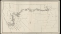 WPRR 1910 Timetable
 -
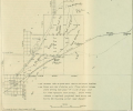 1913 map showing Trego
 -
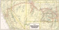 ca. 1914 Map of the Denver and Rio Grande Western Railroad and Western Pacific Railroad
 -
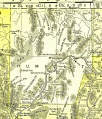
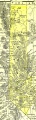 1895 U.S. Atlas - Washoe County
 -
 1895 U.S. Atlas - Humboldt County


See Also
- Maps - Links to modern maps.