Gibson: Difference between revisions
Jump to navigation
Jump to search
Map |
GNIS for Gibson |
||
| Line 8: | Line 8: | ||
== References == | == References == | ||
<references/> | <references/> | ||
* [[ http://geonames.usgs.gov/apex/f?p=gnispq:3:::NO::P3_FID:846197 | GNIS]] "Gibson (Historical)" | |||
** Citation: U.S. Department of the Interior, U.S. Geological Survey, 1:125,000-scale topographic maps; various edition dates. Represents new or changed names from published editions. Map name and year of publication follow (if known): Wadsworth/1894 | |||
Revision as of 04:19, 17 May 2015
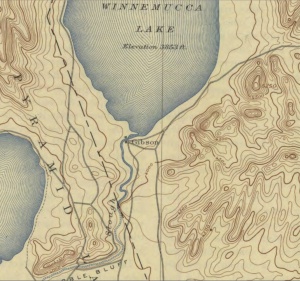
Gibson is a historical location at the south end of Winnemucca Lake.[1]
Formerly owned by Felix McCormack, Gibson was named by W. D. C Gibson, the Indian Agent at Pyramid Lake.[2]
In 1888, W. D. C. Gibson, announced that he had taken over McCormack's and intended to open a resort and trading post.[3]

References
- ↑ "Wadsworth (1894, Rp. 1942)," Map, Mary B. Ansari Map Library, University of Nevada, Reno.
- ↑ Gae Whitney Canfield, "Sarah Winnemucca of the Northern Paiutes."
- ↑ "Stories from the files Forty Years Ago Today," Reno Evening Gazette, July 21, 1928.
- [[ http://geonames.usgs.gov/apex/f?p=gnispq:3:::NO::P3_FID:846197 | GNIS]] "Gibson (Historical)"
- Citation: U.S. Department of the Interior, U.S. Geological Survey, 1:125,000-scale topographic maps; various edition dates. Represents new or changed names from published editions. Map name and year of publication follow (if known): Wadsworth/1894