Fly Geyser: Difference between revisions
→Geology: Added Carpenter Collection |
→Geology: Miller photos |
||
| Line 52: | Line 52: | ||
** UNRS-P1988-55-722 "Reservoir Fountain" 24 miles north of Gerlach to east ¼ mile of Nevada 34 Highway. 18 May 1946. | ** UNRS-P1988-55-722 "Reservoir Fountain" 24 miles north of Gerlach to east ¼ mile of Nevada 34 Highway. 18 May 1946. | ||
** UNRS-P1988-55-78 "Reservoir Fountain" 24 miles north of Gerlach. East ¼ mile Nevada Highway 34, Washoe County. 18 May 1946. | ** UNRS-P1988-55-78 "Reservoir Fountain" 24 miles north of Gerlach. East ¼ mile Nevada Highway 34, Washoe County. 18 May 1946. | ||
* [http://knowledgecenter.unr.edu/materials/specoll/photodesc.aspx?AccNo=UNRS-P1997-51 UNR Thomas Woodnutt Miller]: 2154 - 2158 "Geyser, northern Washoe County between Gerlach and Littlefield." ? | |||
[[Category:Wikipedia articles]] | [[Category:Wikipedia articles]] | ||
Revision as of 06:31, 13 November 2013
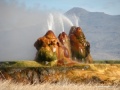
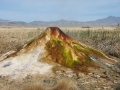
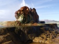
The Fly Ranch was first homesteaded in the late 1800s by Fred Gerlach, son of Louis Gerlach, for whom the town of Gerlach was named. Later it was a part of the John Casey estate, until it was sold to Todd Jaksick (Bright Holland Corporation) in 1998. The feature known as "Fly Geyser" has attracted a substantial amount of interest since it developed from a leaking geothermal well into a striking colorful spouting statue, sitting on a dais of mud amidst ponds of warm water and thriving plants. The property is generally off limits to visitors because of liability and vandalism concerns.
In September, 2010, there was a plan to buy Fly Geyser, see Archive.org: 13 May 2011 http://gotgeyser.com.
http://flyranchproject.org/ discusses Burning Man efforts at purchasing the land.
-
 Fly Geyser, Feb 1965
 -
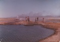 Fly Geyser, 1975
 -
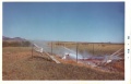
 March 24, 2007
 -
 March 24, 2007
 -
 March 24, 2007
 -
 2010 (Wikipedia)


See Also
Resources
- Wikipedia
- Google Map
- Las Vegas Sun, January 29, 2010 "Geyser on private land chosen as attraction to draw tourists to state."
- November 2001 Reno Gazette Journal article
Images
- Fly Geyser Nevada (cmdrmark.com)
- pictures (cmdrmark.com)
- Online Fly Geyser Jigsaw Puzzle
- http://green.nationalgeographic.com/environment/wallpaper/blackrockgeysermineral.html
- Some older photos
- Nevada's Last Chance Scenic Places
- Smithsonian National Museum of Natural History: photography, "Nature's Best" Landscape Winner
- Virtual Reality views
- http://www.uga.edu/srel/Nevada_Hot_Springs/travel-4-2004.htm
- http://blog.visitrenotahoe.com/2006/06/14/fly-geyser-one-of-nevadas-little-surprises/
- http://planetoddity.com/a-geyser-not-like-any-other-geyser/
- http://www.kuriositas.com/2010/12/fly-geyser-not-quite-of-this-world.html
- http://www.pixelchrome.com/blog/?p=5369
- http://www.wonders-world.com/2011/02/fly-geyser-in-black-rock-desert.html
Geology
- Nevada Bureau of Mines and Geology Geothermal slides including Fly Geyser
- Fly Ranch section of Larry J. Garside, John Harold Schilling, Mackay School of Mines, "Thermal waters of Nevada," Volume 91 of Bulletin (Nevada Bureau of Mines and Geology)
- Archive.org version of the above with working links to some of the images.
- Washoe County chapter of "Thermal waters of Nevada"
- 2005 Public notice about a meeting to discuss injecting Portable Toilet water from Burning Man at Fly Ranch: Public Notice, Authorization to Apply Portable Toilet Fluid (Permit), Wiki version of the notice
- UNR Carpenter Collection Descriptions
- UNRS-P1988-55-1095 "Reservoir fountain twenty-four miles north of Gerlach." (Includes Photo)
- UNRS-P1988-55-737 "Reservoir Fountain" 24 miles north of Gerlach to east ¼ mile of Nevada 34 Highway. 18 May 1946."
- UNRS-P1988-55-722 "Reservoir Fountain" 24 miles north of Gerlach to east ¼ mile of Nevada 34 Highway. 18 May 1946.
- UNRS-P1988-55-78 "Reservoir Fountain" 24 miles north of Gerlach. East ¼ mile Nevada Highway 34, Washoe County. 18 May 1946.
- UNR Thomas Woodnutt Miller: 2154 - 2158 "Geyser, northern Washoe County between Gerlach and Littlefield." ?