Historic Maps: Difference between revisions
Jump to navigation
Jump to search
Link to Fremont map |
Berkeley's copy |
||
| Line 3: | Line 3: | ||
* 1842 [[John C. Fremont]] | * 1842 [[John C. Fremont]] | ||
** [http://www.davidrumsey.com/luna/servlet/detail/RUMSEY~8~1~1818~170044# Map Of An Exploring Expedition To The Rocky Mountains in the Year 1842, Oregon & North California In The Years 1843-44. By Brevet Capt. J. C. Fremont Of The Corps Of Topographical Engineers Under the orders of Col. J.J. Abert, Chief Of The Topographical Bureau. Lith. by E. Weber & Co. Baltimore, Md.] (David Rumsey), shows [[Gerlach "Great Boiling" Springs]] | ** [http://www.davidrumsey.com/luna/servlet/detail/RUMSEY~8~1~1818~170044# Map Of An Exploring Expedition To The Rocky Mountains in the Year 1842, Oregon & North California In The Years 1843-44. By Brevet Capt. J. C. Fremont Of The Corps Of Topographical Engineers Under the orders of Col. J.J. Abert, Chief Of The Topographical Bureau. Lith. by E. Weber & Co. Baltimore, Md.] (David Rumsey), shows [[Gerlach "Great Boiling" Springs]] | ||
** UC Berkeley has a copy [http://oskicat.berkeley.edu/record=b10568020~S1 Map 100.W4 D no.1] | |||
* 1855 Survey | * 1855 Survey | ||
** [[Humboldt Mountains to the Mud Lakes (1855)]] | ** [[Humboldt Mountains to the Mud Lakes (1855)]] | ||
Revision as of 05:12, 14 March 2013
This page provides links to historic maps of the area. For modern maps, see http://blackrockdesert.org/maps/.
- 1842 John C. Fremont
- Map Of An Exploring Expedition To The Rocky Mountains in the Year 1842, Oregon & North California In The Years 1843-44. By Brevet Capt. J. C. Fremont Of The Corps Of Topographical Engineers Under the orders of Col. J.J. Abert, Chief Of The Topographical Bureau. Lith. by E. Weber & Co. Baltimore, Md. (David Rumsey), shows Gerlach "Great Boiling" Springs
- UC Berkeley has a copy Map 100.W4 D no.1
- 1855 Survey
- 1863 DeGroot's map of Nevada (David Rumsey)
- 1883 Lake Lahontan by Israel C. Russell (UNR)
- 1895 U.S. Atlas
- 1896 Post Route Map
- 1918 Map of Lake Lahontan, showing water area and boundary of hydrographic basin from "Fishes of the Lahontan System of Nevada and Northeastern California" map is by Israel C. Russell, probably a duplicate of the 1883 version?(University of Washington)
Gallery
-
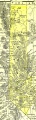 1895 U.S. Atlas - Washoe County
 -
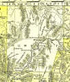 1895 U.S. Atlas - Humboldt County

See Also
- Maps - Links to modern maps.