Historic Maps: Difference between revisions
Jump to navigation
Jump to search
Link at the top to the main website |
Link to 1883 Lake Lahontan map |
||
| Line 6: | Line 6: | ||
** [http://www.davidrumsey.com/luna/servlet/detail/RUMSEY~8~1~23817~920002:Valley-of-the-Mud-Lakes-showing-eig Valley of the Mud Lakes showing eighty two miles of the projected rail road line...] (David Rumsey) | ** [http://www.davidrumsey.com/luna/servlet/detail/RUMSEY~8~1~23817~920002:Valley-of-the-Mud-Lakes-showing-eig Valley of the Mud Lakes showing eighty two miles of the projected rail road line...] (David Rumsey) | ||
* 1863 [http://www.davidrumsey.com/luna/servlet/detail/RUMSEY~8~1~1260~110042:DeGroot-s-Map-Of-Nevada-Territory-E DeGroot's map of Nevada] (David Rumsey) | * 1863 [http://www.davidrumsey.com/luna/servlet/detail/RUMSEY~8~1~1260~110042:DeGroot-s-Map-Of-Nevada-Territory-E DeGroot's map of Nevada] (David Rumsey) | ||
* 1883 [http://contentdm.library.unr.edu/cdm4/item_viewer.php?CISOROOT=/hmaps&CISOPTR=1800&REC=18 Lake Lahontan] by Israel C. Russell (UNR) | |||
* 1895 U.S. Atlas | * 1895 U.S. Atlas | ||
** [http://blackrockdesert.org/wiki/index.php?title=File:1895_U.S._Atlas_-_Washoe_County.jpg 1895 U.S. Atlas - Washoe County] | ** [http://blackrockdesert.org/wiki/index.php?title=File:1895_U.S._Atlas_-_Washoe_County.jpg 1895 U.S. Atlas - Washoe County] | ||
** [http://blackrockdesert.org/wiki/index.php?title=File:1895_U.S._Atlas_-_Humboldt_County.jpg 1895 U.S. Atlas - Humboldt County] | ** [http://blackrockdesert.org/wiki/index.php?title=File:1895_U.S._Atlas_-_Humboldt_County.jpg 1895 U.S. Atlas - Humboldt County] | ||
* [[1896 Post Route Map]] | * [[1896 Post Route Map]] | ||
* 1918 [http://content.lib.washington.edu/u?/fishimages,38976 Map of Lake Lahontan, showing water area and boundary of hydrographic basin] from "Fishes of the Lahontan System of Nevada and Northeastern California" | * 1918 [http://content.lib.washington.edu/u?/fishimages,38976 Map of Lake Lahontan, showing water area and boundary of hydrographic basin] from "Fishes of the Lahontan System of Nevada and Northeastern California" map is by Israel C. Russell, probably a duplicate of the 1883 version?(University of Washington) | ||
=== Gallery === | |||
<gallery> | <gallery> | ||
File:1895_U.S._Atlas_-_Washoe_County.jpg|1895 U.S. Atlas - Washoe County | File:1895_U.S._Atlas_-_Washoe_County.jpg|1895 U.S. Atlas - Washoe County | ||
Revision as of 20:46, 23 November 2012
This page provides links to historic maps of the area. For modern maps, see http://blackrockdesert.org/maps/.
- 1855 Survey
- 1863 DeGroot's map of Nevada (David Rumsey)
- 1883 Lake Lahontan by Israel C. Russell (UNR)
- 1895 U.S. Atlas
- 1896 Post Route Map
- 1918 Map of Lake Lahontan, showing water area and boundary of hydrographic basin from "Fishes of the Lahontan System of Nevada and Northeastern California" map is by Israel C. Russell, probably a duplicate of the 1883 version?(University of Washington)
Gallery
-
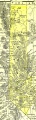 1895 U.S. Atlas - Washoe County
 -
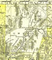 1895 U.S. Atlas - Humboldt County

See Also
- Maps - Links to modern maps.