Ronda: Difference between revisions
Jump to navigation
Jump to search
m Text replacement - "http://geonames.usgs.gov/pls/gnispublic/f?p=gnispq:3:::NO::P3_FID:" to "https://edits.nationalmap.gov/apps/gaz-domestic/public/summary/" |
|||
| Line 13: | Line 13: | ||
== Resources == | == Resources == | ||
* [ | * [https://edits.nationalmap.gov/apps/gaz-domestic/public/summary/843348 GNIS] | ||
** Citation: "U.S. Geological Survey. Geographic Names Post Phase I Map Revisions. Various editions. 01-Jan-2000." | ** Citation: "U.S. Geological Survey. Geographic Names Post Phase I Map Revisions. Various editions. 01-Jan-2000." | ||
** Variant: Ronda Siding. Citation: "U.S. Geological Survey. Geographic Names Phase I data compilation (1976-1981). 31-Dec-1981. Primarily from U.S. Geological Survey 1:24,000-scale topographic maps (or 1:25K, Puerto Rico 1:20K) and from U.S. Board on Geographic Names files. In some instances, from 1:62,500 scale or 1:250,000 scale maps." | ** Variant: Ronda Siding. Citation: "U.S. Geological Survey. Geographic Names Phase I data compilation (1976-1981). 31-Dec-1981. Primarily from U.S. Geological Survey 1:24,000-scale topographic maps (or 1:25K, Puerto Rico 1:20K) and from U.S. Board on Geographic Names files. In some instances, from 1:62,500 scale or 1:250,000 scale maps." | ||
Latest revision as of 21:01, 28 December 2021
Ronda is a siding between Cholona and Sulphur.
Carlson states that Ronda may be named for a commune in southern Spain[1]
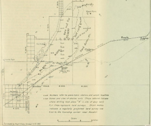
About Ronda, the 1914-1915 WPRR Descriptive Time Table states: "Along the right-of-way hereabouts oil claims have been staked."[2] See Oil Wells.


References
- ↑ Helen S. Carlson, "Nevada Place Names: A Geographical Dictionary," p. 205.
- ↑ "Descriptive Time Tables, Denver and Rio Grande - Western Pacific, Winter 1914-1915."
Resources
- GNIS
- Citation: "U.S. Geological Survey. Geographic Names Post Phase I Map Revisions. Various editions. 01-Jan-2000."
- Variant: Ronda Siding. Citation: "U.S. Geological Survey. Geographic Names Phase I data compilation (1976-1981). 31-Dec-1981. Primarily from U.S. Geological Survey 1:24,000-scale topographic maps (or 1:25K, Puerto Rico 1:20K) and from U.S. Board on Geographic Names files. In some instances, from 1:62,500 scale or 1:250,000 scale maps."