Tohakum Peak: Difference between revisions
Jump to navigation
Jump to search
Tohakum 2 fire |
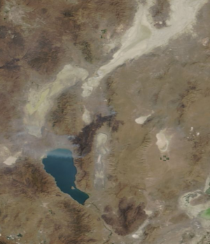
Image of the burn scar |
||
| Line 3: | Line 3: | ||
Carlson states that Tohakum means hare or white rabbit.<ref>Helen S. Carlson, "[https://books.google.com/books?id=BixwbIM7ZvAC&lpg=PA3&ots=KQGs0gb1yh&dq=tohakum%20white%20rabbit%20paiute&pg=PA3#v=onepage&q=tohakum&f=false Nevada Place Names]," p. 3.</ref> | Carlson states that Tohakum means hare or white rabbit.<ref>Helen S. Carlson, "[https://books.google.com/books?id=BixwbIM7ZvAC&lpg=PA3&ots=KQGs0gb1yh&dq=tohakum%20white%20rabbit%20paiute&pg=PA3#v=onepage&q=tohakum&f=false Nevada Place Names]," p. 3.</ref> | ||
In 2017, The Tohakum 2 fire burned at least 52,704 acres. On August 29, 2017 at 7:28 p.m., it started near mile marker 30 of Highway 447. 447 was closed until 7:30am on August 31, 2017 | In 2017, The Tohakum 2 fire burned at least 52,704 acres. On August 29, 2017 at 7:28 p.m., it started near mile marker 30 of Highway 447. 447 was closed until 7:30am on August 31, 2017. | ||
[[File:BlackRockDesert2017-09-01ShowingTohakum2Fire.png|thumb|The Tohakum2 fire is shown in this satellite image from https://worldview.earthdata.nasa.gov/ dated September 1, 2017. In this image, the burn scar can be seen running north east from Pyramid Lake, crossing highway 447 and the Selenite Range.]] | |||
== References == | == References == | ||
<references/> | <references/> | ||
Revision as of 03:13, 2 September 2017
Tohakum Peak is located in the Lake Range.
Carlson states that Tohakum means hare or white rabbit.[1]
In 2017, The Tohakum 2 fire burned at least 52,704 acres. On August 29, 2017 at 7:28 p.m., it started near mile marker 30 of Highway 447. 447 was closed until 7:30am on August 31, 2017.

References
- ↑ Helen S. Carlson, "Nevada Place Names," p. 3.