Old Razorback Mountain: Difference between revisions
Clean up references. |
Pershing County Assessors map is dated 1973. |
||
| Line 22: | Line 22: | ||
* Peggy McGuckian Jones, "[http://www.blm.gov/pgdata/etc/medialib/blm/nv/cultural/reports/technical_reports.Par.7382.File.dat/06_Emigrant_Trails_Black_Rock_Desert.pdf Emigrant Trails In the Black Rock Desert, Technical Report No. 6]," 1980, BLM. Includes image of Township 33 North, Range 25 East plat. Internet copy is of too low a resolution to be useful. | * Peggy McGuckian Jones, "[http://www.blm.gov/pgdata/etc/medialib/blm/nv/cultural/reports/technical_reports.Par.7382.File.dat/06_Emigrant_Trails_Black_Rock_Desert.pdf Emigrant Trails In the Black Rock Desert, Technical Report No. 6]," 1980, BLM. Includes image of Township 33 North, Range 25 East plat. Internet copy is of too low a resolution to be useful. | ||
* Corpsfuds, [http://www.corpsfuds.com/reports/other/J09NV1116realPropertyReport.pdf Lovelock South Gunnery Range Real Property Report]," p. 106. The Pershing County Assessors Map for T 33 N, R 25 E shows "Mt. Trego". | * Corpsfuds, [http://www.corpsfuds.com/reports/other/J09NV1116realPropertyReport.pdf Lovelock South Gunnery Range Real Property Report]," p. 106. The Pershing County Assessors Map for T 33 N, R 25 E shows "Mt. Trego". | ||
* [http://www.pershingcountynv.net:5442/docs/BK2PG10.tif Pershing County Assessors Book 2, Page 10] shows "Mt. Trego" | * [http://www.pershingcountynv.net:5442/docs/BK2PG10.tif Pershing County Assessors Book 2, Page 10] (1973_ shows "Mt. Trego" | ||
* Gibbs, "[http://www.davidrumsey.com/luna/servlet/s/5bd142 California and Nevada]," Map, 1881. "Boiling Butte" might be a name for the Old Razorback Mountain. | * Gibbs, "[http://www.davidrumsey.com/luna/servlet/s/5bd142 California and Nevada]," Map, 1881. "Boiling Butte" might be a name for the Old Razorback Mountain. | ||
Revision as of 02:45, 9 June 2014
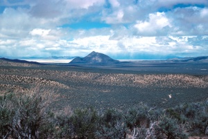
Old Razorback Mountain (5495 ft.) is located south of Trego and Frog (Garrett Ranch) Springs.
The GNIS cites the name as "Original township survey plats, published in the 1800's. 1950". The mountain is in Township 33 North, Range 25 East. Unfortunately, the Plats of Nevada State Lands does not include that Township. Jones (1980) includes that township, but the scans on the web are of too low quality to decipher.
The mountain is also known as "Mount Trego", "Trego Mountain", and "Trego Peak" and as "Sleeping Elephant". Trego Peak and Sleeping Elephant are not commonly used.
The 1881 Gibbs map of California and Nevada indicates that "Boiling Butte" might be another name for the mountain. In 1903, Griffiths described the flora found on Boiling Butte.

External Links
- GNIS, Map
- Citation: Original township survey plats, published in the 1800's. 1950
- Variant: Mount Trego. Citation: Carlson, Helen S., 'Nevada Place Names, A Geographical Dictionary,' Reno, Nevada: University of Nevada Press, 1974, 282 pp. Reference work giving historical background on place names in Nevada. p234
- Pershing County Road Map, 1954. Shows "Old Razorback Mtn."
- David Griffiths, "Forage Conditions and Problems in Eastern Washington Eastern Oregon Northeastern California and Northwestern Nevada," p. 25, US Department of Agriculture, 1903. A thorough description of the flora found on Boiling Butte and the Granite Range.
- Helen S. Carlson, Nevada Place Names: A Geographical Dictionary," p. 234. The entry for Trego says that Trego is at the foot of Mount Trego.
- Carlson cites Trego, Robert, "Black Rock Desert Roads," Nevada State Journal, October 23, 1955, p10-11, which mentions Trego
- Carlson cites "General Highway Maps. Prepared by Nevada State Highway Departmet, Planning and Survey Division, in cooperation with U.S. Department of Commerce, Bureau of Public Roads 1959-1971 (GHM)," p.260.
- Pershing County Road Map, 1954. Shows "Old Razorback Mtn."
- Peggy McGuckian Jones, "Emigrant Trails In the Black Rock Desert, Technical Report No. 6," 1980, BLM. Includes image of Township 33 North, Range 25 East plat. Internet copy is of too low a resolution to be useful.
- Corpsfuds, Lovelock South Gunnery Range Real Property Report," p. 106. The Pershing County Assessors Map for T 33 N, R 25 E shows "Mt. Trego".
- Pershing County Assessors Book 2, Page 10 (1973_ shows "Mt. Trego"
- Gibbs, "California and Nevada," Map, 1881. "Boiling Butte" might be a name for the Old Razorback Mountain.