Trego: Difference between revisions
Jump to navigation
Jump to search
Added categories |
Link to Emigrant Trails West, added Hot Springs Category. |
||
| Line 18: | Line 18: | ||
* [http://maps.yahoo.com/beta/#mvt=s&trf=0&lon=-119.117256&lat=40.771665&mag=1 yahoo map] | * [http://maps.yahoo.com/beta/#mvt=s&trf=0&lon=-119.117256&lat=40.771665&mag=1 yahoo map] | ||
* [http://terraserver.homeadvisor.msn.com/image.aspx?T=1&S=10&Z=11&X=1606&Y=22577&W=1 terraserver] | * [http://terraserver.homeadvisor.msn.com/image.aspx?T=1&S=10&Z=11&X=1606&Y=22577&W=1 terraserver] | ||
* [http://emigranttrailswest.org/virtual-tour/nobles-trail/ Nobles Trail] (Emigrant Trails West) "Trego Springs - Marker N-4" | |||
| Line 27: | Line 28: | ||
[[Category:Ghost towns]] | [[Category:Ghost towns]] | ||
[[Category:Nobles Trail]] | |||
[[Category:Hot Springs]] | |||
Revision as of 16:56, 31 December 2013
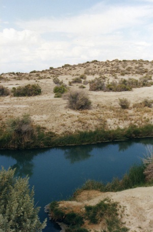
One of many hot springs modified by heavy machinery which line the edges of the Black Rock desert the Trego Trench, as it is commonly known, has wild variations in temperature, with little consistency.
It is on public land part of the Black Rock Desert-High Rock Canyon National Conservation Area, right next to the railroad right of way and crossing.
Crossing the playa at Trego can present a hazard as it is hard to see oncoming train traffic.
Camping is at permitted at designated sites. Fire rings are provided

See Also
External Resources
- nbmg.unr.edu/geothermal Trego Hot Springs
- google map
- yahoo map
- terraserver
- Nobles Trail (Emigrant Trails West) "Trego Springs - Marker N-4"