Gerlach Geothermal Development Project: Difference between revisions
Added image of map. |
Added mention of Dooby Lane. |
||
| Line 1: | Line 1: | ||
The '''Gerlach Geothermal Development Project''' is a [[Geothermal]] project that started in 2020. | The '''Gerlach Geothermal Development Project''' is a [[Geothermal]] project that started in 2020. | ||
The project would add two 24 megawatt (total) power plants with 23 wells, 4.6 miles of pipeline, roads and a powerline to the [[San Emidio Desert]] plants.<ref>[https://www.rgj.com/story/news/2020/10/26/gerlach-residents-geothermal-plant-threatens-dark-skies-near-burning-man/5997894002/ Gerlach residents say the Black Rock's dark skies threatened by proposed geothermal plant,]" Amy Alonzo, Reno Gazette Journal, October 26, 2020.</ref> | The project would add two 24 megawatt (total) power plants with 23 wells, 4.6 miles of pipeline, roads and a powerline to the [[San Emidio Desert]] plants.<ref name=Alonzo2020>[https://www.rgj.com/story/news/2020/10/26/gerlach-residents-geothermal-plant-threatens-dark-skies-near-burning-man/5997894002/ Gerlach residents say the Black Rock's dark skies threatened by proposed geothermal plant,]" Amy Alonzo, Reno Gazette Journal, October 26, 2020.</ref> | ||
Some Gerlach residents are concerned about the effect the plants and wells would have on the viewshed, night skies and water supplies. | Some Gerlach residents are concerned about the effect the plants and wells would have on the viewshed, night skies and water supplies. | ||
| Line 7: | Line 7: | ||
On October 1, 2020, the BLM accepted pre-scoping comments for 60 days.<ref>"[https://www.blm.gov/press-release/bureau-land-management-accepting-pre-scoping-comments-geothermal-project-near-gerlach Bureau of Land Management accepting pre-scoping comments for geothermal project near Gerlach,]" BLM Website.</ref> | On October 1, 2020, the BLM accepted pre-scoping comments for 60 days.<ref>"[https://www.blm.gov/press-release/bureau-land-management-accepting-pre-scoping-comments-geothermal-project-near-gerlach Bureau of Land Management accepting pre-scoping comments for geothermal project near Gerlach,]" BLM Website.</ref> | ||
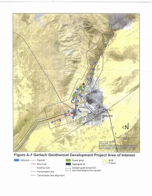
In 2020, the proposed map showed well pads located on the west side of [[Highway 34]], near [[Dooby Lane]],<ref name=Alonzo2020/> located at [https://geohack.toolforge.org/geohack.php?pagename=Dooby_Lane¶ms=40_40_43.1_N_119_21_40.3_W_region:US_type:landmark 40° 40′ 43.1″ N, 119° 21′ 40.3″ W] in section 3, just north of where 34 crosses the boundary between section 3 and section 10. | |||
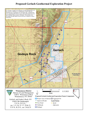
[[Image:Gerlach Geothermal Exploration Map 508 0.png|thumb|Gerlach Geothermal Exploration Map from the December 2021 BLM request for comments]] | On December 10, 2021, the BLM solicited comments on the project<ref>"[https://www.blm.gov/press-release/black-rock-field-office-soliciting-public-comment-gerlach-geothermal-project Black Rock Field Office soliciting public comment on the Gerlach Geothermal Project,]", BLM Website.</ref> and provided a [https://www.blm.gov/sites/blm.gov/files/docs/2021-12/Gerlach_Geothermal%20Exploration_Map_508_0.pdf map] (reproduced below). | ||
[[Image:OrmatGerlachProposal2020-Map.jpg|thumb|Ormat Gerlach Proposal Map from 2020]] | |||
In the December 2021 map some of the proposed well pads moved across Highway 34, away from Dooby Lane. | |||
[[Image:Gerlach Geothermal Exploration Map 508 0.png|thumb|Gerlach Geothermal Exploration Map from the December 2021 BLM request for comments.]] | |||
[[Image:OrmatGerlachProposal2020-Map.jpg|thumb|Ormat Gerlach Proposal Map from 2020.]] | |||
==External links== | ==External links== | ||
Revision as of 18:09, 17 December 2021
The Gerlach Geothermal Development Project is a Geothermal project that started in 2020.
The project would add two 24 megawatt (total) power plants with 23 wells, 4.6 miles of pipeline, roads and a powerline to the San Emidio Desert plants.[1]
Some Gerlach residents are concerned about the effect the plants and wells would have on the viewshed, night skies and water supplies.
On October 1, 2020, the BLM accepted pre-scoping comments for 60 days.[2]
In 2020, the proposed map showed well pads located on the west side of Highway 34, near Dooby Lane,[1] located at 40° 40′ 43.1″ N, 119° 21′ 40.3″ W in section 3, just north of where 34 crosses the boundary between section 3 and section 10.
On December 10, 2021, the BLM solicited comments on the project[3] and provided a map (reproduced below).
In the December 2021 map some of the proposed well pads moved across Highway 34, away from Dooby Lane.


External links
- Gerlach, Nevada Geothermal Energy Zones
- Hilltop Energy Resources LLC Geothermal Energy Zones has a number of leases
- Ormat Gerlach Proposal Letter BLM, October 1, 2020. ( local copy)
- Dark Skies, Tourism Threatened in Gerlach, Nevada Wilderness.
- Ormat concerned stakeholder discussion (Friends of Black Rock/High Rock)
References
- ↑ 1.0 1.1 Gerlach residents say the Black Rock's dark skies threatened by proposed geothermal plant," Amy Alonzo, Reno Gazette Journal, October 26, 2020.
- ↑ "Bureau of Land Management accepting pre-scoping comments for geothermal project near Gerlach," BLM Website.
- ↑ "Black Rock Field Office soliciting public comment on the Gerlach Geothermal Project,", BLM Website.