Highway 34: Difference between revisions
Jump to navigation
Jump to search
Details about Lovelock map |
78-79 map shows the 34 gap |
||
| (9 intermediate revisions by the same user not shown) | |||
| Line 2: | Line 2: | ||
* [https://en.wikipedia.org/wiki/Nevada_State_Route_34 Nevada State Route 34] (Wikipedia) | * [https://en.wikipedia.org/wiki/Nevada_State_Route_34 Nevada State Route 34] (Wikipedia) | ||
* "[http://www.northvalleys.org/txt/hwashoe.pdf History of Washoe County]," "By 1909 the Western Pacific Railroad tracks had reached Gerlach from Winnemucca and the board of county commissioners voted $10,000 for the construction of a wagon road from Surprise Valley, California, to Gerlach 'so that it would become an important trading place.'" (From Carlson, "Place Names of Nevada", p. 154.) | * "[http://www.northvalleys.org/txt/hwashoe.pdf History of Washoe County]," "By 1909 the Western Pacific Railroad tracks had reached Gerlach from Winnemucca and the board of county commissioners voted $10,000 for the construction of a wagon road from Surprise Valley, California, to Gerlach 'so that it would become an important trading place.'" (From Carlson, "Place Names of Nevada", p. 154. Also, "[http://www.northvalleys.org/txt/hwashoe.pdf History of Washoe County]", which sources Myrick, Vol. 1, pp. 318-319; Reno Evening Gazette, Nov. 9, 1909. ) | ||
* Larry Wilson, "[http://www.dailysparkstribune.com/view/full_story/10550153/article-Small-towns-hit-the-%E2%80%98bust%E2%80%99-in-Nevada%E2%80%99s-%E2%80%98boom-and-bust%E2%80%99-history?instance=secondary_story_left_column Small towns hit the ‘bust’ in Nevada’s ‘boom and bust’ history]," Sparks Tribune, 2011. "The first time I went to the area was in the mid-1950s. In those days, the road was gravel once you got past the sand dunes north of Nixon, an Indian community 50 or so miles south of Gerlach." | * Larry Wilson, "[http://www.dailysparkstribune.com/view/full_story/10550153/article-Small-towns-hit-the-%E2%80%98bust%E2%80%99-in-Nevada%E2%80%99s-%E2%80%98boom-and-bust%E2%80%99-history?instance=secondary_story_left_column Small towns hit the ‘bust’ in Nevada’s ‘boom and bust’ history]," Sparks Tribune, 2011. "The first time I went to the area was in the mid-1950s. In those days, the road was gravel once you got past the sand dunes north of Nixon, an Indian community 50 or so miles south of Gerlach." | ||
* John Burns, Frank Johnson. "[http://newspaperarchive.com/nevada-state-journal/1953-04-26/page-7 Residents of Gerlach Like to Think of It As One of the last Genuine Frontier Towns]," Nevada State Journal, April 26, 1953, Page 7. "J. J. Thrasher, ... says the solution to Gerlach's problem lies in completed the paving of Highway 34 to the south and the surfacing of highway 81 north to the California line near Eagleville." | * John Burns, Frank Johnson. "[http://newspaperarchive.com/nevada-state-journal/1953-04-26/page-7 Residents of Gerlach Like to Think of It As One of the last Genuine Frontier Towns]," Nevada State Journal, April 26, 1953, Page 7. "J. J. Thrasher, ... says the solution to Gerlach's problem lies in completed the paving of Highway 34 to the south and the surfacing of highway 81 north to the California line near Eagleville." | ||
* The [https://www.lib.utexas.edu/maps/topo/250k/txu-pclmaps-topo-us-lovelock-1962.jpg 1:250,000 Lovelock/1962 map] shows the pavement ending just south of Empire. The map was created with photogrammetric methods in | * Nevada State Journal, Thursday, March 18, 1954, [http://newspaperarchive.com/nevada-state-journal/1954-03-18/page-3 Page 3]. "The road is already surfaced from Reno to Empire" | ||
* Peggy Trego, "[ | * [http://contentdm.library.unr.edu/u?/hmaps,499 Official highway map of the state of Nevada (1955)] shows the Highway 34 pavement ending at or just south of [[Empire]]. | ||
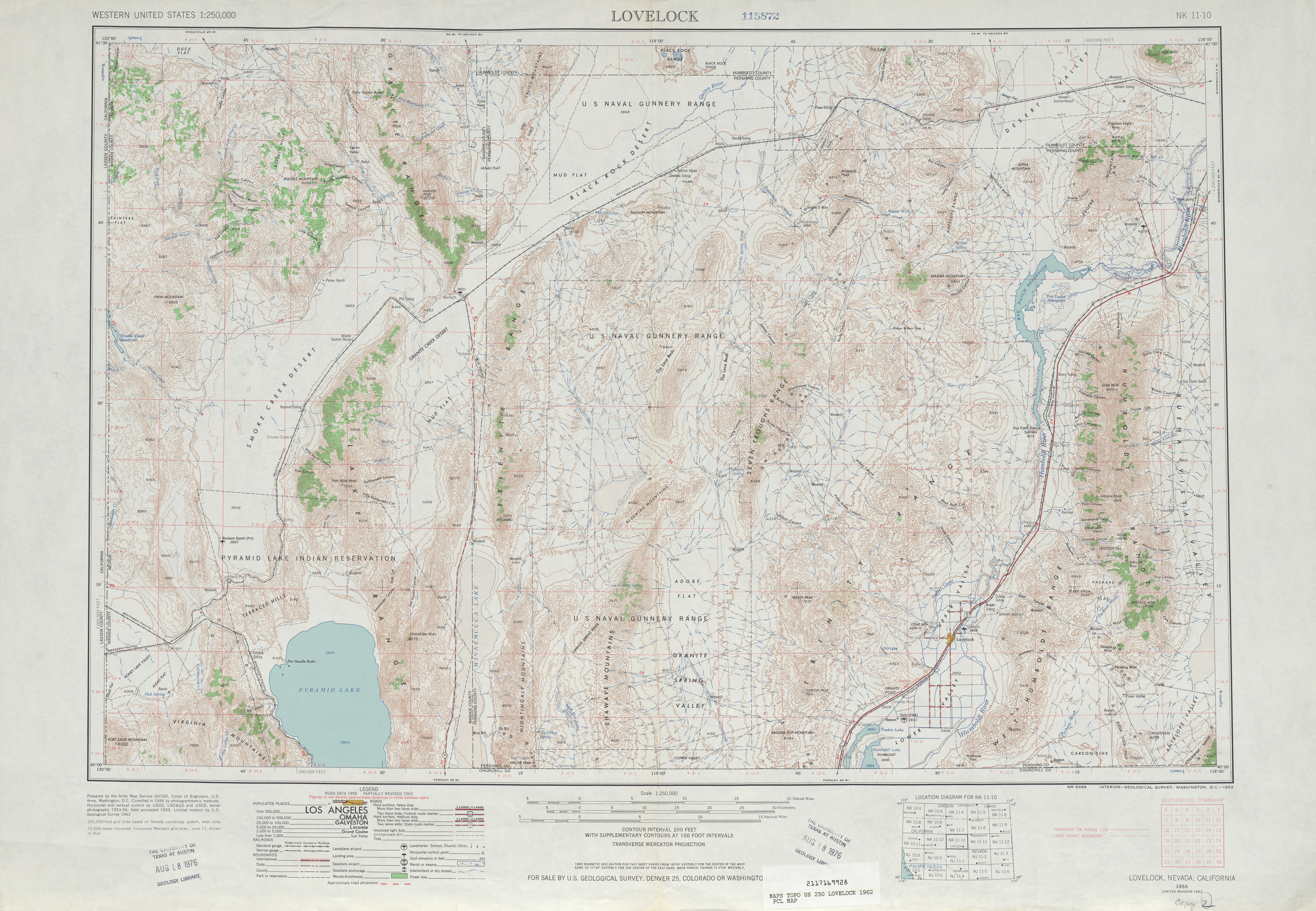
* The [https://www.lib.utexas.edu/maps/topo/250k/txu-pclmaps-topo-us-lovelock-1962.jpg 1:250,000 Lovelock/1962 map] shows the pavement ending just south of Empire. The map was created with photogrammetric methods in 1956. Aerial photography in 1953-54. Field annotated 1955. Limited revision in 1962 | |||
* Peggy Trego, "[[Desert_Magazine#November.2C_1960 |The 40 Wilderness Miles North of Gerlach, Nevada]]," Desert Magazine, November, 1960. "...except that Gerlach is 111 miles northerly of Reno, and can be reached by pavement on Nevada's State Route 34." | |||
* W.C. Sinclair, "[http://images.water.nv.gov/images/publications/recon%20reports/rpt20-black_rock_desert.pdf Ground Water Appraisal of the Black Rock Desert Area, Northwestern Nevada]," October, 1963. "State Route 34 is paved from Gerlach south to U.S. 40. ... State Route 81 is also paved part of the 55 miles from Gerlach to the California State Line and to Cedarville, 25 miles beyond." | * W.C. Sinclair, "[http://images.water.nv.gov/images/publications/recon%20reports/rpt20-black_rock_desert.pdf Ground Water Appraisal of the Black Rock Desert Area, Northwestern Nevada]," October, 1963. "State Route 34 is paved from Gerlach south to U.S. 40. ... State Route 81 is also paved part of the 55 miles from Gerlach to the California State Line and to Cedarville, 25 miles beyond." | ||
* The [http://contentdm.library.unr.edu/u?/hmaps,513 Official highway map of Nevada (1963-1964)] shows 34 paved until about [[Squaw Reservoir]]. | |||
* The [http://contentdm.library.unr.edu/u?/hmaps,515 Official highway map of Nevada (1965-1966)] shows a few more miles of pavement. | |||
* The [http://contentdm.library.unr.edu/u?/hmaps,523 Official highway map of Nevada (1970)] shows an unpaved gap north of Gerlach and then pavement to the state line. | |||
* The [http://contentdm.library.unr.edu/u?/hmaps,535 Official highway map of Nevada (1978-1979)] shows 34 as paved all the way through, whereas the previous shows the gap. | |||
Latest revision as of 02:24, 2 March 2014
Highway 34 is the old name for Nevada State Route 447.
- Nevada State Route 34 (Wikipedia)
- "History of Washoe County," "By 1909 the Western Pacific Railroad tracks had reached Gerlach from Winnemucca and the board of county commissioners voted $10,000 for the construction of a wagon road from Surprise Valley, California, to Gerlach 'so that it would become an important trading place.'" (From Carlson, "Place Names of Nevada", p. 154. Also, "History of Washoe County", which sources Myrick, Vol. 1, pp. 318-319; Reno Evening Gazette, Nov. 9, 1909. )
- Larry Wilson, "Small towns hit the ‘bust’ in Nevada’s ‘boom and bust’ history," Sparks Tribune, 2011. "The first time I went to the area was in the mid-1950s. In those days, the road was gravel once you got past the sand dunes north of Nixon, an Indian community 50 or so miles south of Gerlach."
- John Burns, Frank Johnson. "Residents of Gerlach Like to Think of It As One of the last Genuine Frontier Towns," Nevada State Journal, April 26, 1953, Page 7. "J. J. Thrasher, ... says the solution to Gerlach's problem lies in completed the paving of Highway 34 to the south and the surfacing of highway 81 north to the California line near Eagleville."
- Nevada State Journal, Thursday, March 18, 1954, Page 3. "The road is already surfaced from Reno to Empire"
- Official highway map of the state of Nevada (1955) shows the Highway 34 pavement ending at or just south of Empire.
- The 1:250,000 Lovelock/1962 map shows the pavement ending just south of Empire. The map was created with photogrammetric methods in 1956. Aerial photography in 1953-54. Field annotated 1955. Limited revision in 1962
- Peggy Trego, "The 40 Wilderness Miles North of Gerlach, Nevada," Desert Magazine, November, 1960. "...except that Gerlach is 111 miles northerly of Reno, and can be reached by pavement on Nevada's State Route 34."
- W.C. Sinclair, "Ground Water Appraisal of the Black Rock Desert Area, Northwestern Nevada," October, 1963. "State Route 34 is paved from Gerlach south to U.S. 40. ... State Route 81 is also paved part of the 55 miles from Gerlach to the California State Line and to Cedarville, 25 miles beyond."
- The Official highway map of Nevada (1963-1964) shows 34 paved until about Squaw Reservoir.
- The Official highway map of Nevada (1965-1966) shows a few more miles of pavement.
- The Official highway map of Nevada (1970) shows an unpaved gap north of Gerlach and then pavement to the state line.
- The Official highway map of Nevada (1978-1979) shows 34 as paved all the way through, whereas the previous shows the gap.