Cane Springs (Paiute Meadows): Difference between revisions
Jump to navigation
Jump to search
Added a link to the survey plat image. |
No edit summary |
||
| (5 intermediate revisions by the same user not shown) | |||
| Line 1: | Line 1: | ||
Cane Springs is located south of Paiute Meadows, near [[Elephant Mountain]] on the east edge of the [[Black Rock Range]]. | Cane Springs is located south of [[Paiute Meadows]], near [[Elephant Mountain]] on the east edge of the [[Black Rock Range]]. | ||
Note that there is also a [[Cane Springs (Division Peak)]]. | Note that there is also a [[Cane Springs (Division Peak)]]. | ||
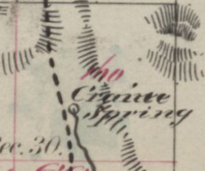
[[File:CraineSpring1873Survey.png|thumb|Craine Spring, from the 1873 Survey Plat]] | [[File:CraineSpring1873Survey.png|thumb|Craine Spring, from the 1873 Survey Plat]] | ||
Bancroft (1890) lists Cane Spring as one of the towns and settlements in Humboldt County.<ref>Hubert Howe Bancroft, "[https://hdl.handle.net/2027/aeu.ark:/13960/t2697nh5z?urlappend=%3Bseq=307 History of Nevada, Colorado, Wyoming, 1540-1888]," p. 264, 1890.</ref>. This Cane Spring could be [[Amos]], located near the junction of 140 and US 95. | |||
== References == | == References == | ||
* [ | <references/> | ||
** Craine Spring: Citation "Original township survey plats, published in the 1800's. 1873" | * [https://edits.nationalmap.gov/apps/gaz-domestic/public/summary/857458 GNIS] | ||
** Craine Spring: Citation "[https://glorecords.blm.gov/details/survey/default.aspx?dm_id=389148&sid=tkxyaaua.2fa Original township survey plats, published in the 1800's. 1873" (S30 T39N R27E) | |||
** Cain Springs: Citation: "Bureau of Land Management (BLM) maps other than 1:100,000-scale and 1:126,720-scale (1/2 inch = 1 mile). The name and year of publication follow (if known): Salem Westside Recreation Map 1996 Bartlett Creek/1972" | ** Cain Springs: Citation: "Bureau of Land Management (BLM) maps other than 1:100,000-scale and 1:126,720-scale (1/2 inch = 1 mile). The name and year of publication follow (if known): Salem Westside Recreation Map 1996 Bartlett Creek/1972" | ||
*** "Cain Springs": [https://www.nevadadot.com/uploadedFiles/NDOT/About_NDOT/NDOT_Divisions/Engineering/Location/Documents/Quads/1971_Atlas/quad0210.pdf NV DOT 1971 Atlas 2/10] | *** "Cain Springs": [https://www.nevadadot.com/uploadedFiles/NDOT/About_NDOT/NDOT_Divisions/Engineering/Location/Documents/Quads/1971_Atlas/quad0210.pdf NV DOT 1971 Atlas 2/10] | ||
Latest revision as of 13:57, 3 June 2023
Cane Springs is located south of Paiute Meadows, near Elephant Mountain on the east edge of the Black Rock Range.
Note that there is also a Cane Springs (Division Peak).

Bancroft (1890) lists Cane Spring as one of the towns and settlements in Humboldt County.[1]. This Cane Spring could be Amos, located near the junction of 140 and US 95.
References
- ↑ Hubert Howe Bancroft, "History of Nevada, Colorado, Wyoming, 1540-1888," p. 264, 1890.
- GNIS
- Craine Spring: Citation "[https://glorecords.blm.gov/details/survey/default.aspx?dm_id=389148&sid=tkxyaaua.2fa Original township survey plats, published in the 1800's. 1873" (S30 T39N R27E)
- Cain Springs: Citation: "Bureau of Land Management (BLM) maps other than 1:100,000-scale and 1:126,720-scale (1/2 inch = 1 mile). The name and year of publication follow (if known): Salem Westside Recreation Map 1996 Bartlett Creek/1972"
- "Cain Springs": NV DOT 1971 Atlas 2/10
- "Cain Springs": NV DOT 1960 Humboldt County, Zone 2 (not present in 1937 Zone 2)
- Cain Spring: Citation: "U.S. Geological Survey. Geographic Names Phase I data compilation (1976-1981). 31-Dec-1981. Primarily from U.S. Geological Survey 1:24,000-scale topographic maps (or 1:25K, Puerto Rico 1:20K) and from U.S. Board on Geographic Names files. In some instances, from 1:62,500 scale or 1:250,000 scale maps."
- Sinclair, "Ground Water Appraisal of the Black Rock Desert Area," 1963.
- Granite Spring: "U.S. Geological Survey. Geographic Names Phase I data compilation (1976-1981). 31-Dec-1981. Primarily from U.S. Geological Survey 1:24,000-scale topographic maps (or 1:25K, Puerto Rico 1:20K) and from U.S. Board on Geographic Names files. In some instances, from 1:62,500 scale or 1:250,000 scale maps."