Heslip: Difference between revisions
Jump to navigation
Jump to search
m Fixed GNIS |
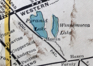
1931 WP map shows the station as Heslin. |
||
| (6 intermediate revisions by the same user not shown) | |||
| Line 1: | Line 1: | ||
Heslip was a stop on the [[Fernley and Lassen Railway]], between [[Libby]] and [[Romolo]].<ref>[http://www.railwaystationlists.co.uk/pdfusarr/nevadarrs.pdf Nevada Railroads SL-171 Passenger Stations and Stops]</ref><ref>Helen S. Carlson, "[https://books.google.com/books?id=BixwbIM7ZvAC&lpg=PA179&ots=KQDtUke2wf&dq=Heslip%20nevada%20-brady&pg=PA134#v=onepage&q=Heslip&f=false Nevada Place Names: A Geographical Dictionary]", p. 133.</ref> | Heslip was a stop on the [[Fernley and Lassen Railway]], between [[Libby]] and [[Romolo]].<ref>Rand McNally, "[http://www.davidrumsey.com/luna/servlet/s/nm8v0k Nevada]," 1924.</ref><ref>[http://www.railwaystationlists.co.uk/pdfusarr/nevadarrs.pdf Nevada Railroads SL-171 Passenger Stations and Stops]</ref><ref>Helen S. Carlson, "[https://books.google.com/books?id=BixwbIM7ZvAC&lpg=PA179&ots=KQDtUke2wf&dq=Heslip%20nevada%20-brady&pg=PA134#v=onepage&q=Heslip&f=false Nevada Place Names: A Geographical Dictionary]", p. 133.</ref> | ||
In 1956, Southern Pacific requested permission to abandon the Heslip siding, located 9 miles west of [[Sutcliffe]].<ref>"[http://newspaperarchive.com/us/nevada/reno/nevada-state-journal/1956/12-16/page-18?tag=heslip&rtserp=tags/heslip?psi=63&pci=7 Siding Abandonment is requested by SP]," December 16, 1956, p. 18.</ref> | |||
[[File:Portion of WP in Nevada 1931 map showing "Heslin", a typo for Hesip.png|thumb|The 1931 Western Pacific map shows this station as "Heslin."]] | |||
== References == | == References == | ||
<references/> | <references/> | ||
== Resources == | == Resources == | ||
* [ | * [https://edits.nationalmap.gov/apps/gaz-domestic/public/summary/846281 GNIS] (historical) | ||
** "Description: RR siding" | ** "Description: RR siding" | ||
** Citation: "County Base Map Series, Nevada Department of Transportation, historic (1930's). | ** Citation: "[https://www.nevadadot.com/uploadedFiles/NDOT/Traveler_Info/Maps/washoecounty1937_001.pdf County Base Map Series, Nevada Department of Transportation, historic (1930's). WA1/1937]" | ||
[[Category:Fernley and Lassen Railway]] | [[Category:Fernley and Lassen Railway]] | ||
[[Category:GNIS]] | |||
[[Category:Railroad sidings]] | [[Category:Railroad sidings]] | ||
Latest revision as of 01:50, 28 January 2023
Heslip was a stop on the Fernley and Lassen Railway, between Libby and Romolo.[1][2][3]
In 1956, Southern Pacific requested permission to abandon the Heslip siding, located 9 miles west of Sutcliffe.[4]

References
- ↑ Rand McNally, "Nevada," 1924.
- ↑ Nevada Railroads SL-171 Passenger Stations and Stops
- ↑ Helen S. Carlson, "Nevada Place Names: A Geographical Dictionary", p. 133.
- ↑ "Siding Abandonment is requested by SP," December 16, 1956, p. 18.
Resources
- GNIS (historical)
- "Description: RR siding"
- Citation: "County Base Map Series, Nevada Department of Transportation, historic (1930's). WA1/1937"