File:Satellite 5-4-1993 WetDry 7,4,2-labels.png
Jump to navigation
Jump to search

Size of this preview: 657 × 600 pixels. Other resolution: 1,000 × 913 pixels.
Original file (1,000 × 913 pixels, file size: 1.55 MB, MIME type: image/png)
Summary
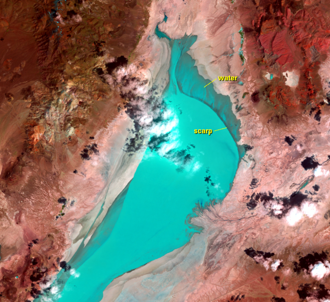
From https://eros.usgs.gov/media-gallery/earthshot/wet-dry-cycle
"An image from May 4, 1993, shows an interesting effect. Water from that year’s temporary lake was blown out of its bed to the north by a strong south wind. A shallow scarp, only 20–40 centimeters high, curves around the north edge of the playa and often marks the edge of the lake. But the blue color washes over the scarp in this image."
File history
Click on a date/time to view the file as it appeared at that time.
| Date/Time | Thumbnail | Dimensions | User | Comment | |
|---|---|---|---|---|---|
| current | 15:49, 19 February 2023 | | 1,000 × 913 (1.55 MB) | Cxbrx (talk | contribs) | From https://eros.usgs.gov/sites/eros.usgs.gov/files/earthshot/Black_Rock_Playa/5-4-1993_WetDry_7%2C4%2C2-labels.png From https://eros.usgs.gov/media-gallery/earthshot/wet-dry-cycle "An image from May 4, 1993, shows an interesting effect. Water from that year’s temporary lake was blown out of its bed to the north by a strong south wind. A shallow scarp, only 20–40 centimeters high, curves around the north edge of the playa and often marks the edge of the lake. But the blue color washes over... |
You cannot overwrite this file.
File usage
The following page uses this file: